Page 1 of 3
2017 Satellite Imaging
Posted: Tue Jan 31, 2017 10:34 pm
by internetscooter
Sorry guys for the quietness - I won't be going to the lake this year

I have just started a new job and have a lab only 80% built with 0% done on the Vespa inside.
I am still at Monash and still have access to super computers - so I will see what I can do with what little time I have.
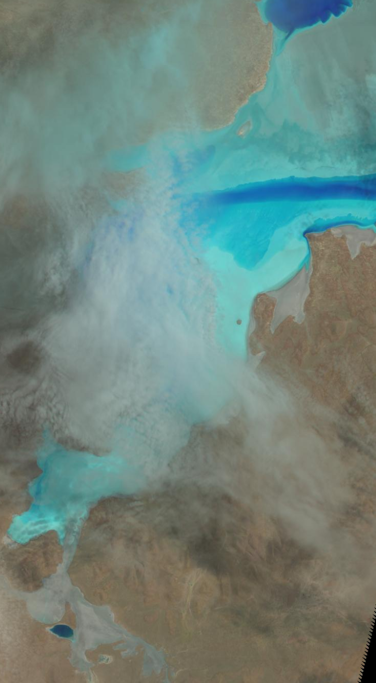
Here is the natural image from
ORIGIN = "Image courtesy of the U.S. Geological Survey"
REQUEST_ID = "0501701291279_00022"
LANDSAT_SCENE_ID = "LC81000822017030LGN00"
FILE_DATE = 2017-01-30T04:44:55Z
Full download cropped
http://files.internetscooter.com/dlra/2 ... ropped.jpg
Preview
Re: 2017 Satellite Imaging
Posted: Tue Jan 31, 2017 10:57 pm
by DLRA
Thank Paul, your efforts are always appreciated
Re: 2017 Satellite Imaging
Posted: Wed Feb 01, 2017 11:10 am
by David Leikvold
Thanks Paul,
Thanks for the image. We'll miss you at Track 2. Maybe next year? Apropos of nothing, I can't help wondering about that bright blue stripe running east to west. Presumably it's a water filled channel, has anyone ever been that far north? I wonder if it would be like the Dead Sea in Israel / Jordan, where the water is a saturated solution of salt and offers incredible buoyancy.
www.youtube.com/watch?v=aTcyACmiaho
See you all soon,
Dave

Re: 2017 Satellite Imaging
Posted: Wed Feb 01, 2017 4:19 pm
by Lynchy
Dave
Yes it would be super buoyant - I almost regret one year that we went out to find just under a foot of water on the lake. I wanted to test it out as a massive float tank but it was toooooo cold. There's one for the first timers. Pack a jacket and some cold weather gear, it can get really cold at times.
Re: 2017 Satellite Imaging
Posted: Wed Feb 01, 2017 7:07 pm
by David Leikvold
Paul,
One day when we've got nothing to do (HA!) we should organise an expedition to head up there and try it out. Perhaps late one afternoon after racing has finished for the day. We'd just have to remember to stop before we drove into the channel. And bring something to read for the photos.
Cheers
Dave
Re: 2017 Satellite Imaging
Posted: Thu Feb 02, 2017 8:57 am
by Lynchy
Dave
My kids gave Liz and myself a voucher at Christmas for a spa treatment at Noosa Springs. It includes a splash in their float tank followed by a massage and drinks.
So - do I go with Liz.............. or Dave........
Sorry Dave, Liz won! I'm sure you'll get over it?
Re: 2017 Satellite Imaging
Posted: Thu Feb 02, 2017 10:36 am
by David Leikvold
Take Liz,
Please 
!
I was looking at Google maps and, unsurprisingly, there aren't any dirt tracks that head up north towards the Blue Channel, which seems as good a name as any. It would make more sense to drive on the dirt than the salt, I remember Chris Hanlon telling stories of heading north on the salt and finding themselves suddenly bogging down in soft salt and only getting out with a quick U-turn and full throttle. He also said that it gets decidedly dodgy when you go out far enough to lose sight of "dry land", unless you have a compass or a GPS or you can find your own wheel tracks, things can get nasty very quickly.
If a track was cut it could become a tourist attraction and money spinner for the Newtons. If I see Len this year I'll mention it to him.
Cheers
Dave
Re: 2017 Satellite Imaging
Posted: Thu Feb 02, 2017 11:39 am
by David Leikvold
Actually, when I zoomed into the map tightly enough to see individual trees I dd find a track that comes off the road to the Drivers Camp that heads north and gets within about six kilometres of the closest land to the Blue Channel before it loops away to the east. There may even be more track there but it is very hard to see anything man made. I'll bet Trevor Beck could get us there.
Re: 2017 Satellite Imaging
Posted: Thu Feb 02, 2017 8:55 pm
by momec3
Never take that place for granted. What Dave says, when you get out 20 miles north. All you can see for 360 degrees is salt. No land.
Re: 2017 Satellite Imaging
Posted: Thu Feb 02, 2017 9:54 pm
by penny
David , one christmas we walked out the back gate of the members camp on the road north . We would have walked for 1.5 hrs and we were going nowhere so we turned back . When coming back i saw the radio tower and decided to leave the road and go in a straight line back to the members .Thats when i found the old mine shaft over the generator hill .
I will revisit google earth and try to follow the road again . Paul Penny
Re: 2017 Satellite Imaging
Posted: Fri Feb 03, 2017 12:42 am
by David Leikvold
Getting anywhere around on the dirt would definitely have to be in a vehicle. Any walking across country would be asking for trouble, it wouldn't be easy to recognise landmarks on the way back. Take a GPS with marked waypoints and plenty of water. I like walking on the salt, I'm easily amused so I like to close my eyes for 30 seconds or so and see if I can walk in a straight line. I can't. No wonder people get lost out in the bush.
Re: 2017 Satellite Imaging
Posted: Mon Feb 06, 2017 12:36 pm
by DocScooter
Hey folks,
That picture is entirely consistent with what I saw from the air at about the same time. There is certainly a deeper patch running across the Lake at that level.
I'm doing another flight on Wednesday 9th.... I'll go up that far and get some pictures.
Re: 2017 Satellite Imaging
Posted: Mon Feb 06, 2017 5:08 pm
by David Leikvold
Thanks Scott, that would be much appreciated. Are you competing this year?
Cheers
Dave
Re: 2017 Satellite Imaging
Posted: Mon Feb 06, 2017 9:37 pm
by DocScooter
Absolutely.
Our new beast was not going to be completed in time and has been shelved for the moment.....
So long live the Mandarin! It will be back!
Re: 2017 Satellite Imaging
Posted: Thu Feb 09, 2017 10:24 am
by internetscooter
Quick update - here is the overview for today - I will get a closeup when I get some time to download and crop the full data set
