Page 2 of 3
Re: 2017 Satellite Imaging
Posted: Fri Feb 10, 2017 8:44 am
by DLRA
Looks like it would be soft after the 9 again
Re: 2017 Satellite Imaging
Posted: Fri Feb 10, 2017 12:11 pm
by AuotonomousRX
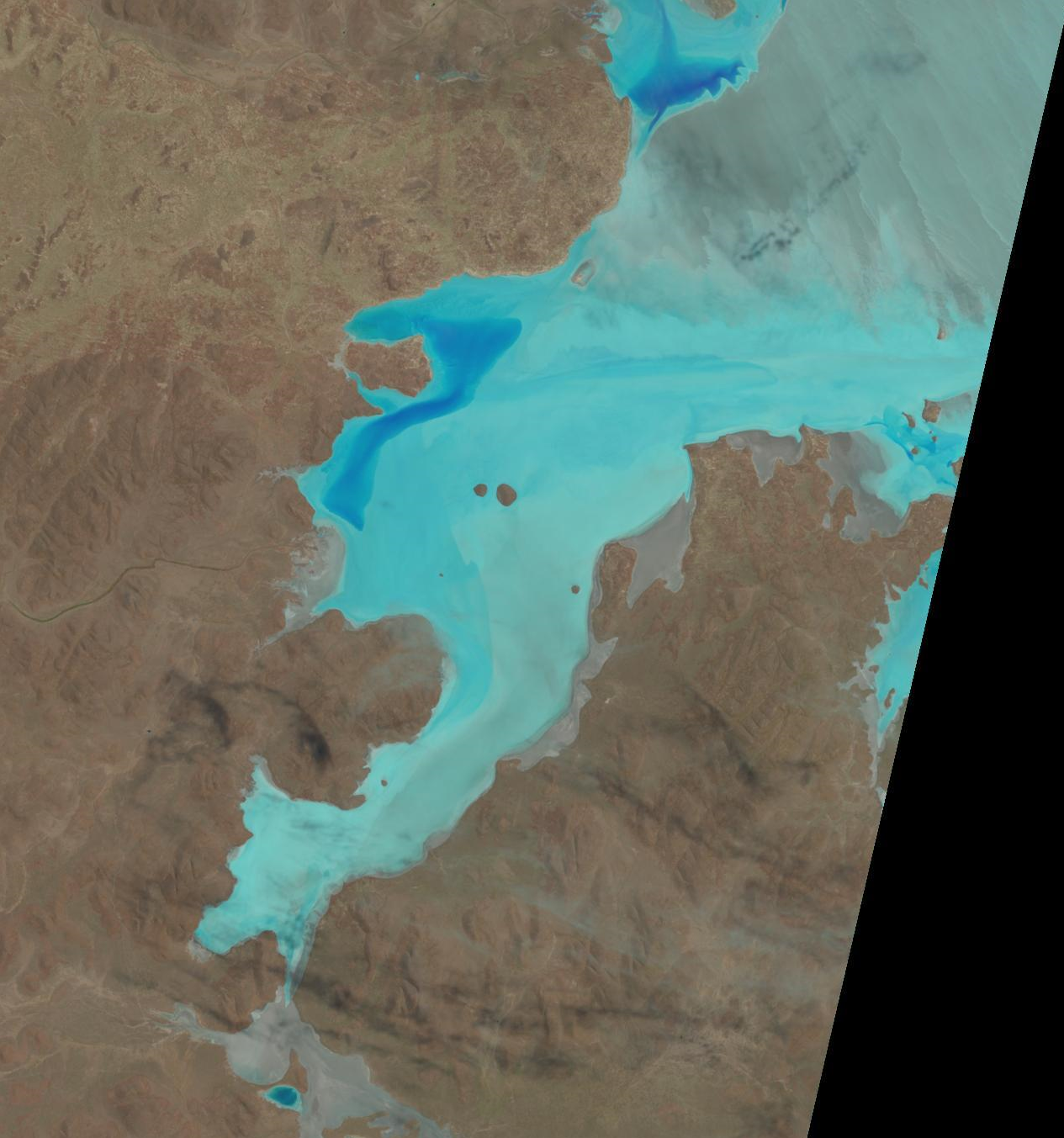
Here is the Landsat Pic 8th Feb 2017

Pete
Re: 2017 Satellite Imaging
Posted: Fri Feb 10, 2017 3:24 pm
by AuotonomousRX
Mt Ive Temps this week so far
Tuesday 37C
Wednesday 44C
Thursday 47C
Pete
Re: 2017 Satellite Imaging
Posted: Fri Feb 10, 2017 3:46 pm
by DocScooter
Hey folks,
That picture is exactly what I saw when I flew the lake yesterday.
The dark blue areas are all standing water, and the rest is dry.
Re: 2017 Satellite Imaging
Posted: Sat Feb 11, 2017 7:01 am
by Greg Watters
Thanks guys, hope the water stays up there .
Pauls pic shows Island Lagoon on top right, often wondered if it would be a viable alternative if Lk G got too complicated
Re: 2017 Satellite Imaging
Posted: Sat Feb 11, 2017 8:40 am
by momec3
Good point Greg.
Any idea o access to Island Lagoon?
Re: 2017 Satellite Imaging
Posted: Sat Feb 11, 2017 11:51 am
by Greg Watters
old Satelite tracking station on the edge has access, but searching for info has it mud in the top half near the tracking station , & near its island , but looks like good salt to run nearly east to west on the longest path , or vise versa
No idea on its ownership status
Re: 2017 Satellite Imaging
Posted: Sat Feb 11, 2017 8:20 pm
by dave leaney
Nearly thirty years ago I went to Island Lagoon in an effort to check out the salt. Drove in to the old tracking station to have a look. It's situated high on a plateau overlooking the lake. Good views but I couldn't find any access down to the surface. What I could see though was that it was all mud, no salt anywhere. If I was going there today I'd check out the southern end, every satellite image I've ever seen has shown the southern end as white as can be.
Re: 2017 Satellite Imaging
Posted: Sat Feb 11, 2017 10:23 pm
by Greg Watters
Thats the bit that catches my eye too
Re: 2017 Satellite Imaging
Posted: Sun Feb 12, 2017 5:35 pm
by mal hewett
About 8 years ago myself and Col Kranz with our young boys got onto the southern end of Island Lagoon . It was ROUGH going . I remember thinking that there was no way a truck or someone towing anything big would be able to use the road we were on . We were in 4 wheel drives.
I go past Island lagoon regularly ,either flying or by road and always check it out . It certainly is a wild sight.
Re: 2017 Satellite Imaging
Posted: Sun Feb 12, 2017 9:00 pm
by DLRA
The area you are talking about is north of the boundary of the part of the lake described in the Act as being set aside for motorsport purposes and a long way from the new "COMMERCIAL PURPOSES" zone that we arexpect now restricted to by DEWNR
Re: 2017 Satellite Imaging
Posted: Thu Feb 16, 2017 10:19 am
by internetscooter
Another update 2017/02/15 - looks like it is drying out...

Re: 2017 Satellite Imaging
Posted: Thu Feb 16, 2017 6:49 pm
by Stayt`ie
ummmm toofar away to tell

Re: 2017 Satellite Imaging
Posted: Thu Feb 16, 2017 8:22 pm
by internetscooter
Just squint a bit

Re: 2017 Satellite Imaging
Posted: Fri Feb 17, 2017 12:52 pm
by Lynchy
Looks like Dave's float tank area is now further to the west..........
