2017 Satellite Imaging
Moderators: DLRA, Rob Carroll, OLDtimer, outbacktrev, Peter Noy
Re: 2017 Satellite Imaging
Looks like it would be soft after the 9 again
Keep the shiney side up........
DLRA WebMaster / Editor
DLRA WebMaster / Editor
-
AuotonomousRX

- Posts: 729
- Joined: Wed Jan 06, 2010 10:05 pm
- Location: Eyre Peninsula SA
Re: 2017 Satellite Imaging
Here is the Landsat Pic 8th Feb 2017

Pete

Pete
Still trying to decide if I am a procrastinator
Pete
DLRA #866
Pete
DLRA #866
-
AuotonomousRX
- Posts: 729
- Joined: Wed Jan 06, 2010 10:05 pm
- Location: Eyre Peninsula SA
Re: 2017 Satellite Imaging
Mt Ive Temps this week so far
Tuesday 37C
Wednesday 44C
Thursday 47C
Pete
Tuesday 37C
Wednesday 44C
Thursday 47C
Pete
Still trying to decide if I am a procrastinator
Pete
DLRA #866
Pete
DLRA #866
-
DocScooter
- Posts: 39
- Joined: Sun Mar 04, 2012 1:06 am
- Location: Wudinna, SA
Re: 2017 Satellite Imaging
Hey folks,
That picture is exactly what I saw when I flew the lake yesterday.
The dark blue areas are all standing water, and the rest is dry.
That picture is exactly what I saw when I flew the lake yesterday.
The dark blue areas are all standing water, and the rest is dry.
Scott Lewis #1128 High Viz Racing
Wudinna Medical Practice - DLRA Medical Support
High Viz Racing Air Wing
Wudinna, SA - Closest to the lake
Wudinna Medical Practice - DLRA Medical Support
High Viz Racing Air Wing
Wudinna, SA - Closest to the lake
-
Greg Watters

- Posts: 760
- Joined: Mon Sep 27, 2004 8:57 pm
Re: 2017 Satellite Imaging
Thanks guys, hope the water stays up there .
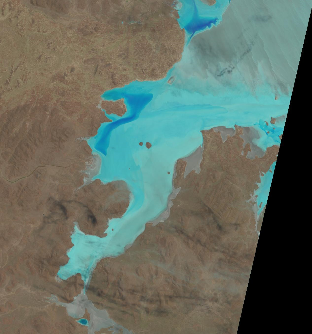
Pauls pic shows Island Lagoon on top right, often wondered if it would be a viable alternative if Lk G got too complicated
Pauls pic shows Island Lagoon on top right, often wondered if it would be a viable alternative if Lk G got too complicated
-
Greg Watters
- Posts: 760
- Joined: Mon Sep 27, 2004 8:57 pm
Re: 2017 Satellite Imaging
old Satelite tracking station on the edge has access, but searching for info has it mud in the top half near the tracking station , & near its island , but looks like good salt to run nearly east to west on the longest path , or vise versa
No idea on its ownership status
No idea on its ownership status
-
dave leaney
- Posts: 18
- Joined: Wed Mar 25, 2009 11:21 pm
Re: 2017 Satellite Imaging
Nearly thirty years ago I went to Island Lagoon in an effort to check out the salt. Drove in to the old tracking station to have a look. It's situated high on a plateau overlooking the lake. Good views but I couldn't find any access down to the surface. What I could see though was that it was all mud, no salt anywhere. If I was going there today I'd check out the southern end, every satellite image I've ever seen has shown the southern end as white as can be.
-
Greg Watters
- Posts: 760
- Joined: Mon Sep 27, 2004 8:57 pm
Re: 2017 Satellite Imaging
Thats the bit that catches my eye too
-
mal hewett
- Posts: 44
- Joined: Mon Feb 27, 2006 2:52 pm
- Location: roxby downs
Re: 2017 Satellite Imaging
About 8 years ago myself and Col Kranz with our young boys got onto the southern end of Island Lagoon . It was ROUGH going . I remember thinking that there was no way a truck or someone towing anything big would be able to use the road we were on . We were in 4 wheel drives.
I go past Island lagoon regularly ,either flying or by road and always check it out . It certainly is a wild sight.
I go past Island lagoon regularly ,either flying or by road and always check it out . It certainly is a wild sight.
- Attachments
-
- 2 Febuary 2017 from the Stuart Highway.jpg (223.91 KiB) Viewed 35164 times
-
- 15 January 2017 after the rains.jpg (150.07 KiB) Viewed 35164 times
Mal Hewett
#234
#234
Re: 2017 Satellite Imaging
The area you are talking about is north of the boundary of the part of the lake described in the Act as being set aside for motorsport purposes and a long way from the new "COMMERCIAL PURPOSES" zone that we arexpect now restricted to by DEWNR
Keep the shiney side up........
DLRA WebMaster / Editor
DLRA WebMaster / Editor
-
internetscooter
- Posts: 475
- Joined: Mon Nov 20, 2006 12:18 pm
- Location: Melbourne
- Contact:
Re: 2017 Satellite Imaging
Another update 2017/02/15 - looks like it is drying out...

Paul
---
DLRA #647
89.664 mph (aiming for 100mph+)
www.vespalabs.org
---
DLRA #647
89.664 mph (aiming for 100mph+)
www.vespalabs.org
Re: 2017 Satellite Imaging
ummmm toofar away to tell
First Australian to ride a motorcycle over 200mph at Bonneville,,,
-
internetscooter
- Posts: 475
- Joined: Mon Nov 20, 2006 12:18 pm
- Location: Melbourne
- Contact:
Re: 2017 Satellite Imaging
Just squint a bit 
Paul
---
DLRA #647
89.664 mph (aiming for 100mph+)
www.vespalabs.org
---
DLRA #647
89.664 mph (aiming for 100mph+)
www.vespalabs.org

Re: 2017 Satellite Imaging
Looks like Dave's float tank area is now further to the west..........