Biodiversity Assessment - Gawler
On this page
- Introduction
- Natural Values
- Wetlands
- Nationally important wetlands
- Regionally important wetlands
- Riparian Zones
- Ecosystems at risk
- Species at risk
- Eucalypts and Acacias
- Birds
- Mammals
- Management responses
- Reserve consolidation
- Off-park conservation for species and ecosystem recovery
- Integrated NRM
- Further information and gaps
Gawler

Introduction
The Gawler bioregion consists of several semi-arid to arid landscapes. In the south are gently undulating calcrete plains and occasional quartzite or granite hills with a zone of salt lakes and gypsum dunes. These grade into the Gawler Ranges, a set low, flat-topped to broadly rounded hills of the Gawler Range Volcanics and Proterozoic sediments. At their northern margin is an undulating upland plain with shallow loamy soils underlain by quartzite and sandstone that includes several vast salt lakes. Interspersed within this are low plateaux on sandstone and quartzite with an undulating surface of aeolian sand or gibbers. Further north are erosional or depositional plains between the Arcoona Plateau and the silcrete tablelands to the north. Prominent vegetation communities include Casuarina pauper (black oak) and Acacia papyrocarpa (western myall) low open woodlands, open mallee scrub, bluebush/saltbush open chenopod shrublands and Acacia aneura (mulga) shrublands on shallow loams, calcareous earths and hard red duplex soils.
Summary of overall condition and trend
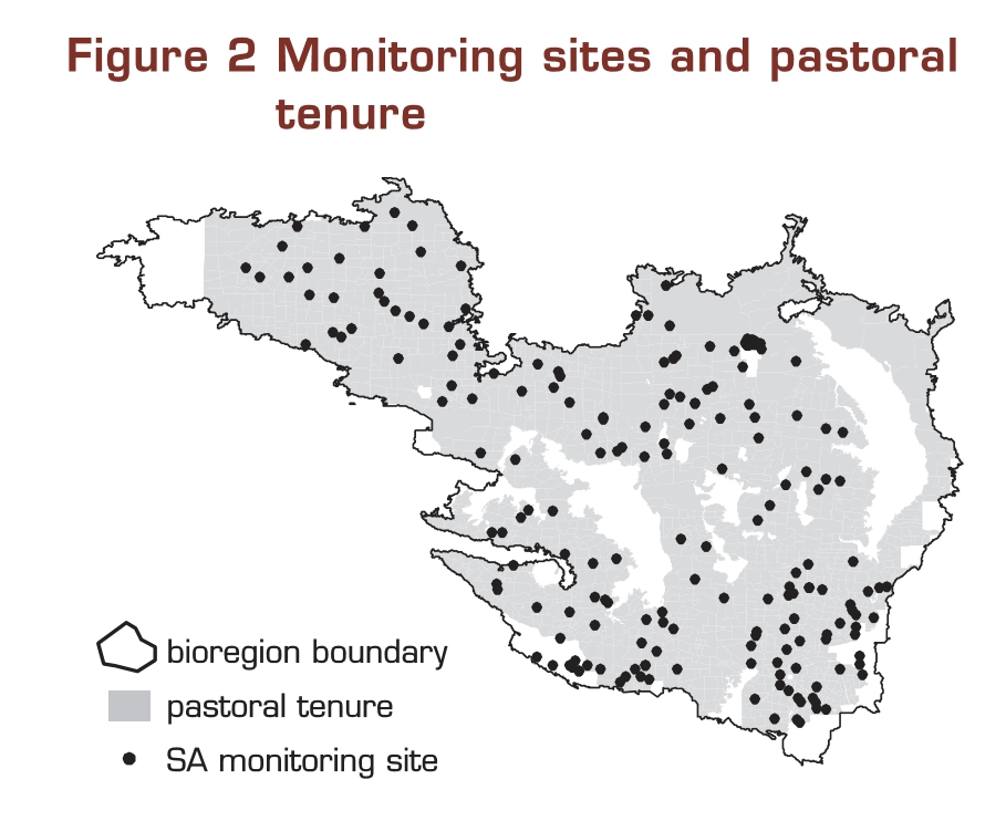
The overall condition of the bioregion is fair and the trend static. The principal land use is sheep grazing on native pastures. A small portion of the bioregion is, however, north of the dog fence. Cattle grazing occurs in these areas. Historical species decline has been related to fox and feral cat predation and habitat degradation associated with grazing by introduced herbivores. The pastoral lease assessment and monitoring program is currently addressing the issue of total grazing pressure, and is a major initiative in pastoral land management and restoration.
The bioregion consists of five subregions (Myall Plains - GAW1, Gawler Volcanics - GAW2, Gawler Lakes - GAW3, Arcoona Plateau - GAW4 and Kingoonya - GAW5). All are continental landscape stress class 3 as assessed by the Landscape Health report (1 is most stressed, 6 is least stressed), except Gawler Lakes, which is 4.
Summary of Conservation Priorities
The sustainable use of rangelands is pivotal to biodiversity conservation as pastoral leases occupy the dominant share of the bioregion and include a wider range of habitats than do the reserves. The creation of new stock water points in previously ungrazed or lightly grazed areas needs to be carefully considered as it may have serious consequences on native species utilising these refuge areas. Feral animal control is also a major issue as fox and feral cat predation and competition for resources with feral goats and rabbits compromise native species populations. Artificially high kangaroo numbers are also a significant component of the total grazing pressure impacting native vegetation communities.
Natural values
The Gawler bioregion is significant as a transitional area between the more mesic flora and fauna of the Eyre Yorke Block bioregion and the arid biota of the northern areas of South Australia. Over 20 bird species reach their northernmost limit and six species their southernmost limit in the Gawler Ranges. The Ranges also represent an area of vegetation transition from the mallee communities to the south and the arid woodlands and shrublands to the north and west. Lakes Torrens and Gairdner are the second and third largest salt lakes in Australia after Lake Eyre and provide important occasional habitat for waterbirds.
The bioregion contains at least nine plant taxa, one bird and one reptile that are endemic. These include Eucalyptus lansdowneana (red-flowering mallee box), Brachycome muelleri (Corunna daisy), Pterostylis ovata (Gawler Ranges greenhood), Amytornis textilis myall (Thick-billed Grasswren) and Nephrurus deleani (Pernatty Knob-tailed Gecko). Also of major significance is an isolated population of Petrogale xanthopus xanthopus (Yellow-footed Rock-wallaby) in the Gawler Volcanics subregion.
Click here to link to a table of natural values within each subregion
Wetlands
The Gawler bioregion contains two wetlands listed in the Directory of Important Wetlands in Australia.
The Upper Spencer Gulf is an inverse estuary containing shallow, warm saline waters and includes the coastal wetland types of marine waters, seagrass meadows, estuarine waters, intertidal mud and sand flats, intertidal marshes, and mangrove swamps. The Avicennia marina var. resinifera (grey mangrove) low open forest at Chinaman Creek is the largest stand of mangroves remaining in South Australia, and the Redcliff region is one of the finest examples of a sub-tropical marine and coastal ecosystem in the Southern Hemisphere. It also contains the richest and most diverse coastal flora in SA.
The Inland Saline Lakes includes Lake Torrens, an intermittent saline lake which, when in flood provides suitable habitat for large wader populations. Lake Torrens is one of the few arid zone areas where large colonies of Cladorhynchus leucocephalus (Banded Stilts) have been known to breed.
Threats to wetlands in the Gawler Bioregion include soil erosion along coastal cliffs and in sand dune areas, past mining activities, vehicle track damage and rabbit grazing of peripheral vegetation.
Nationally important wetlands

Click here to link to a table of Australia's Important Wetlands (Directory of Important Wetlands of Australia): their type, condition, trend and threatening processes within each subregion.
Regionally important wetlands
Table: Provisional identification of wetlands of regional significance: their type and special values within each subregion. The reliability of the overall subregional assessment is indicated.
There is no data available for this table within the bioregion.
Table: Provisional identification of wetlands of regional significance: their condition, trend and threatening processes within each subregion.
There is no data available for this table within the bioregion.
Riparian Zones
There are no major watercourses within this bioregion, though a number of minor drainage lines emanate in the Gawler and Andamooka Ranges. No specific information is available on the riparian zones associated with these though run-on areas in ranges tend to provide a focus for biodiversity, including feral animals and stock. They are therefore likely to only be in, at best, fair condition.
Click here to link to a table of riparian zones: their average condition, trend and threatening processes for each subregion. The reliability of this overall assessment is indicated.
Ecosystems at risk
This bioregion contains three ecosystems assessed as being at risk in SA. These are a mulga woodland, an arid acacia low woodland and a tall shrubland with tussock grass understorey. All are considered to be declining in condition with the principle threats being lack of regeneration and seedling suppression of overstorey dominants due to total grazing pressure.

Click here to link to a table of provisional list of threatened ecosystems in Australia: their broad vegetation type (National Vegetation Information System - Major Vegetation Subgroup), recommended status, current legislative protection as a threatened ecosystem, trend and bioregional distribution. These ecosystems are arranged in the bioregion of their principal occurrence. The reliability of the recommended status is indicated.
Click here to link to a table of provisional list of threatened ecosystems in each subregion: their threatening processes.
Click here to link to a table of provisional list of threatened ecosystems in each subregion: their recommended recovery actions
Species at risk
The main threats to the plants are total grazing pressure and weed invasion. Limited population size and distribution is a further threat to some species as this puts them at risk to local extinction. The birds and mammals are mainly threatened by habitat degradation associated with total grazing pressure and altered fire regimes, and predation by foxes and cats. Threats to the single threatened reptile species, N. deleani, are not definitely known, but rabbit grazing is thought to reduce protective ground cover thus exposing it to predation.
There is a total of 30 threatened species in the Gawler bioregion.
| Taxa Group | National Rating | State/Territory Rating | |||
|---|---|---|---|---|---|
| Endangered | Vulnerable | Endangered | Vulnerable | Total | |
| Plants | 3 | 9 | 0 | 6 | 18 |
| Birds | 0 | 2 | 0 | 5 | 7 |
| Mammals | 1 | 3 | 0 | 0 | 4 |
| Reptiles | 0 | 1 | 0 | 0 | 1 |
| Amphibians | 0 | 0 | 0 | 0 | 0 |
| Total | 4 | 15 | 0 | 11 | 30 |

Click here to link to a table of species at risk in each subregion: their status, trend and subregional distribution. The reliability of the assessment of trend is indicated and whether recovery plans have been prepared.
Click here to link to a table of species at risk in each subregion: their threatening processes.
Click here to link to a table of species at risk in each subregion: their status recommended recovery actions.
Eucalypts and Acacias
The Myall Plains and Gawler Volcanics subregions each contain one endemic eucalypt species, Eucalyptus sp. (Cariewerloo Homestead N.N.Donner 3186) and E. lansdowneana (red-flowered mallee box) respectively. While the latter is in good condition and its trend static, no information is available for the former.
None of the subregions of the Gawler bioregion contain endemic acacias, nor have any been identified as being particularly rich for either of these genera.
Birds
This bioregion encompasses the Gawler Ranges and the predominantly chenopod shrublands to the north, which are little-cleared, but have, in parts, been heavily grazed. At its eastern fringe, the bioregion abuts the Flinders Ranges, providing local habitat for the Vulnerable subspecies of Chestnut-rumped Heathwren. The other limited range and threatened taxa in the bioregion are better represented in other bioregions. There are affinities with southwestern Australia: Western Yellow Robin and Rufous Treecreeper, typical southwestern taxa, are under-represented. There is a moderate load of introduced species, but that may reflect a bias in observations, most of which are likely to have been made in parts of the bioregion that are close to settlements. Few of the guilds show any major trends and the avifauna as a whole probably changed little between Atlas periods.
Status: Semi-arid avifauna with many chenopod shrubland specialists and links to east and west.
Rare and threatened: Chestnut-rumped Heathwren on edge of Flinders Ranges.
Increasers: Crested Pigeon, Long-billed Corella, Musk Lorikeet.
Indicators: Emu, Australian Bustard, Banded Lapwing, White-browed Treecreeper, Jacky Winter, Hooded Robin, Crested Bellbird, Restless Flycatcher, Varied Sittella.
Trend: Ground-feeding insectivores and freshwater birds were recorded less frequently.
Scenario: Possible continued decline of insectivores in the face of continued heavy grazing.
Actions: No grazing in representative areas and the adoption of reduced, conservative grazing rates in key habitat across the bioregion, along with appropriate fire regime to maintain diversity.
Click hereto download a summary report including the physical characteristics of the bioregion, a species list, and summary statistics [Excel file]. The file may open on your screen. To save it to your system 'Save as' under the File menu.
Mammals
Number of species and status
There are 46 mammal species within this bioregion. (The maximum number of species recorded in a bioregion is 86 and the minimum is 25).
Click here to link to a table of number of species in each status class for this bioregion.
Click here to link to a list of mammal species and their status for this bioregion.
Critical weight range
The critical weight range (35 - 5500 g) of mammals is the size range of Australian mammals that have been most affected by environmental changes following European settlement. In this bioregion, the proportion of mammal fauna within the critical weight range is .435. (The maximum proportion of fauna within the critical weight range recorded in a bioregion is 0.632 and the minimum is 0.222).
Faunal Attrition Index
Faunal attrition is a measure of contraction or loss of species richness with a region. A high index value means many species have declined or are extinct in the bioregion. The index can be used to compare the status of mammal fauna to regional attributes such as changes since European settlement and average annual rainfall. The Faunal Attrition Index for mammals in this bioregion is .52. (The maximum faunal attrition index value recorded in a bioregion is 0.66 and the minimum is 0).
Click here to link to a table of Faunal Attrition Index for groups of mammals shows the contributions of each group to overall patterns of faunal decline.
Faunal Contraction Index
A range contraction index is a measure of the extent to which the range inhabited by a particular species has contracted. A high index value means that many of the species comprising the region's original mammal fauna have contracted from a high proportion of the regions they originally occurred in. The faunal contraction index for the mammal fauna in this bioregion is .39. (The maximum faunal contraction index value recorded in a bioregion is 0.51 and the minimum is 0.07).
Faunal Endemism Index
Endemic species are those restricted to certain regions. Regions containing endemic species are considered to have high biodiversity conservation values because opportunities to conserve those species do not exist elsewhere. A high index value means that the species comprising the original mammal fauna typically occurred in few bioregions. The faunal endemism index value for the mammal fauna in this bioregion is .66. (The maximum faunal endemism index value recorded in a bioregion is 0.79 and the minimum is 0.52).
New Endemism Index
Extant (still surviving) species that have undergone major range contractions can be considered 'new endemics'. Bioregions that contain new endemic species are often important refugia for threatened species. The new endemism index for the mammal fauna in this bioregion is .55. (The maximum new endemism index value recorded in a bioregion is 0.93 and the minimum is 0.5).
Table: Translocated Species
There is no data available for this table within the bioregion.
Exotic Mammals
The number of introduced exotic mammal species that occur within this bioregion is 9. (The maximum number of introduced exotic mammal species in a bioregion is 16 and the minimum is 5).
Click here to link to a list of introduced exotic mammal species for this bioregion.
Extinct mammal species
The number of extinct mammal species that previously occurred within this bioregion is 15. (The maximum number of extinct mammal species in a bioregion is 29 and the minimum is 0).
Click here to link to a list of extinct mammal species for this bioregion.
Management responses
Reserve consolidation
There are several major reserves within the bioregion:
- Lake Torrens National Park and Lake Gairdner National Park conserve large playa lakes of a tectonic depression. Vegetation of the lake margins and the large islands of the lakebeds includes low samphire shrublands and tall shrublands over chenopods.
- Gawler Ranges National Park preserves a portion of the ranges previously held as a pastoral lease. The park contains a range of vegetation communities including Acacia aneura, Acacia papyrocarpa and Casurina pauper low woodlands, mallee communities, Triodia irritans (spinifex) hummock grasslands and chenopod shrublands.
- Winninowie Conservation Park conserves excellent examples of several coastal and marine systems in a temperate climate, including significant stands of the Avicennia marina var. resinifera (grey mangrove) and samphire salt marsh communities.
- Lake Gilles Conservation Park and Lake Gilles Conservation Reserve are located in the transitional zone between pastoral and agricultural lands. They contain several major habitats including salt pans, low sandy rises, gypsum dunes, undulating plains and isolated stony hills
Key priority ecosystems for inclusion in future reserves are:-
- Acacia aneura Low Woodland on sand plains
- Alectryon oleifolius ssp. canescens Tall Shrubland on alluvial soils of plains
- Acacia calcicola Low Woodland on calcareous soils of breakaway tablelands
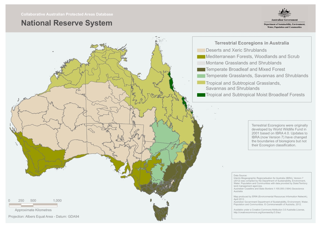
Priority subregions are Arcoona Plateau (0.6% protected) and Kingoonya (3.0% protected). While the Gawler Lakes subregion appears well conserved at 37.6%, it is only the large salt lakes that are in parks and many ecosystems are under-represented.
The main constraints are availability and cost of land and the subsequent management requirements. Over 80% of the bioregion is pastoral lease and reserve consolidation would require loss of pastoral productivity. It is also an area of considerable mineral exploration interest and mineral extraction is expected to be an increasing land use.
Click here to link to a table of comprehensiveness, adequacy and representativeness (CAR) of the National Reserve System in terms of ecosystems and area sampled and a ranking of reserve management. The bioregional priority for consolidating the National Reserve System is based on this CAR analysis and threat.
Click here to link to a table of bioregional and subregional priorities and ecosystem priorities to consolidate the National Reserve System and associated ecosystem constraints.
Off-park conservation for species and ecosystem recovery
The priority species groups are Grasswrens and possibly threatened plants of the ranges. While the recent dedication of Gawler Ranges National Park has resulted in some protection for these species further recovery actions are required across the bioregion. These include habitat retention on pastoral leases (possibly via the establishment of Heritage Agreements), total grazing management, conservative stocking practices and predator control.
The main constraints to this are inadequate resourcing to establish and manage Heritage Agreements and the potential loss of primary production associated with setting aside land for conservation.
Integrated NRM
Key issues for integrated natural resource management in the Gawler bioregion are:-
- ecologically sustainable use of rangelands;
- the creation of new stock watering points in previously ungrazed or lightly grazed areas;
- feral animal control; and
- total grazing management.
Current NRM initiatives include:-
- NHT-funded Bushcare Grants for on-ground biodiversity conservation works;
- a duty of care requirement for pastoral lessees within the Pastoral Land Management and Conservation Act 1989 that details their obligations to land management;
- several major planning mechanisms - Gawler Ranges Soil Conservation District Plan, Kingoonya Soil Conservation District Plan and the Rangelands Regional Biodiversity Plan (currently in preparation)
The priorities for NRM across the bioregion are:-
- proactive targeting of Heritage Agreements to protect priority threatened ecosystems;
- ensure ongoing funding for on-ground biodiversity conservation works;
- feral animal control


Click here to link to a table of contribution of integrated Natural Resource Management to the protection of biodiversity in each subregion: existing measures and effectiveness.
Table: The contribution of integrated Natural Resource Management to the protection of biodiversity in each subregion: feasible opportunities and comments.
There is no data available for this table within the bioregion.
Further Information & Gaps
Data gaps and research priorities
- Systematic flora and fauna survey required for whole bioregion (currently only conducted for small portion).
- Vegetation mapping required at scale consistent with neighbouring bioregions.
- Detailed information on the ecological requirements, threats, trend and condition of many of the threatened species, particularly the plants.
- Detailed information on riparian zone condition, trend and threatening processes.
- Further wetland inventory is required.
References
Environment Australia 2000. Revision of the Interim Biogeographic Regionalisation of Australia (IBRA) and the Development of Version 5.1. - Summary Report. Department of Environment and Heritage, Canberra.
A complete list of references is available by clicking here.
Further information
View the Landscape Health in Australia report.
View the Terrestrial Biodiversity Assessment 2002 report.
Download the Terrestrial Biodiversity Assessment 2002 Database - Biodiversity Audit Data Entry System (BADES), and specifications
Click here to link to a table of some major data gaps in each subregion in terms of protecting biodiversity.
http://www.anra.gov.au/topics/vegetation/assessment/sa/ibra-gawler.html
Last updated: Friday, 16-Nov-2007 10:32:24 EST
Reference Material
- Airports
- Biology
- Climate
- Geography
- Geological
- Government
- History
- Lunar
- Mining
- Native Title
- Salt Lakes of Australia
- Salt / Dry Lakes of the World
- Glossary
Learn More
- Lake Gairdner
- How to get to Lake Gairdner
- Maps of Lake Gairdner
- Rainfall at Lake Gairdner
- Aerial photos from 2006 of a flooded Lake Gairdner
- Reference Material