Geological
Lake Gairdner is an alluviated river valley, it has inflows only from the surrounding catchment, its salt growth is not from leaching / surface water, but comes from subterranean ground water, which is a saturated brine, this ground water is classed as an unconfined aquifer, the lake surface is an outlet of this ground water, this ground water is NOT a part of the great artisian basin which lies much further north, but is a part of an equally large basin called the Weston Plateau Drainage Area, the geology of the lake is from top down to water table, salt, gypsum then gypseous clays, the water table lies an average of 5 meters below the salt surface and has some flowing springs at the surface, factors effecting the water table level include, topography, geology, seasonal & tidal effects and the amount of water pumped /drawn from the aquifer.
The following Geology and Landform information has been summarised from Robinson et al., 1988, Tynan 1995 and Tutty 1993.
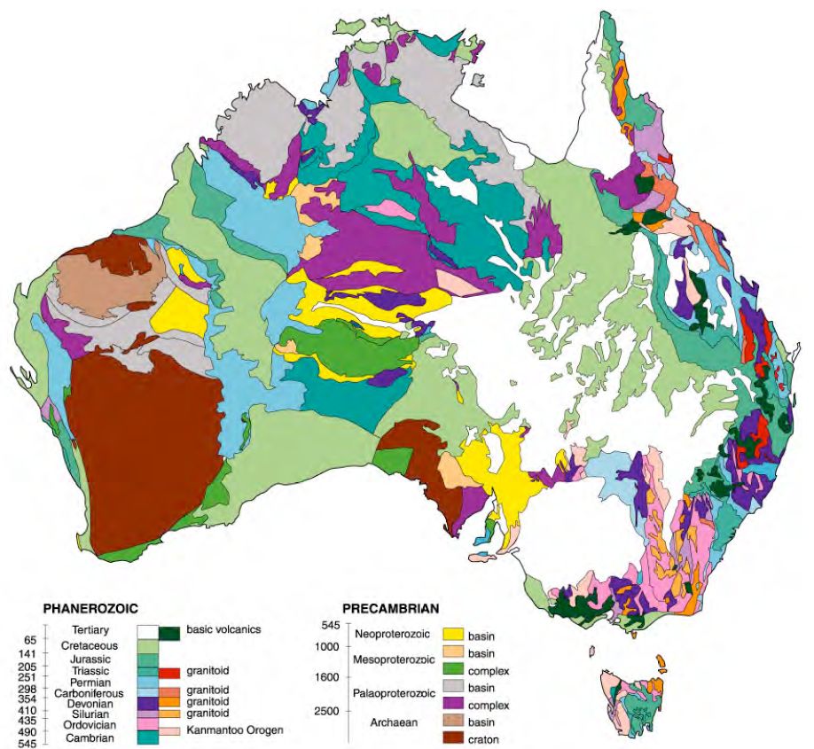
Lake Gairdner National Park is located on the Gawler Craton, an ancient and stable landmass that has not been subject to major tectonic activity for over 1000 million years. The Gawler Craton stretches from near Tarcoola in the north, to the tip of Eyre Peninsula in the south, and was formed as a result of volcanism and igneous activity over a period of 1100 million years. The orogenic (mountain-building) activity had ceased approximately 1580 million years ago but was followed by a period of vulcanism and ash and lava flows.
These extrusions, now called the Gawler Ranges Volcanics, occurred over an area of 25,000 square kilometres about 1525 million years ago. The Gawler Ranges Volcanics underlie and form the elevated southern and western boundaries of the park. A later extrusion of Hiltaba Granite took place about 1480 million years ago.
The rocks are acidic, often fine grained and classified as rhyolite to dacite. The cooling history of some of the lava flows is complex, with both fast and slow periods of cooling giving rise to both large and small crystal sizes in the porphyritic dacites and rhyodacites. The thickness of the extruded Gawler Ranges Volcanics was estimated by Blissett (1975) at 1500 m.
To the east of the park, sediments associated with the Adelaide Geosyncline overlay the Gawler Ranges Volcanics, including the sandstones of the Pandurra Formation, while Cretaceous sandstones of the Cadna-Owie Formation lie on the north shore of Lake Gairdner.
Along the western side of Lakes Everard and Gairdner, the Gawler Ranges Volcanics are overlain by Quaternary aeolian sands derived from, and an extension of, the inland dune fields of the Great Victoria Desert. This long northwest/southeast trending tongue of vegetated dunes re-occurs on the eastern side of Lake Gairdner.
Long periods of weathering have eroded the ranges along typically vertical jointing and established trellis drainage patterns. This structural control of the drainage pattern may also have been caused or accentuated by ring faulting from the impact of the Lake Acraman meteorite, estimated to have had a four-kilometre diameter (Williams, quoted in Robinson et al 1988).
During periods of uplift and higher rainfall, deep valleys were carved into the porphyritic rocks and the drainage system ran deep into the interior of the continent. As the climate changed and rainfall diminished, the elongated river valleys began to fill with sediments. This process continued until the drainage system was infilled and only the tops of the rounded porphyry hills rose above the land surface. The depth of sediments in the valleys has been estimated at 60 m (Garrett 1973). This process of infilling led to the formation of the modern Lake Gairdner.
Today, the drainage pattern is localised, with intermittent streams carrying relatively small amounts of rainfall to the lake. It should be noted that the lake does not receive its salt inflow from surface drainage but from saline groundwater which, through evaporation, deposits sodium chloride (salt) and calcium sulphate (gypsum) at the lake surface.
The surface composition of Lake Gairdner varies considerably. Generally, the lakebed is made up of gypsiferous muds, clays and silts with some gypsum crystals. A layer of salt crust, mostly from 30 mm to 75 mm thick covers this. This crust, however, can range in thickness from a few centimetres to over one metre, although in the northern third of Lake Gairdner and also in parts of Lakes Everard and Harris, there is in fact no identifiable salt crust, the lake surface in most years comprising merely saline clays.
Where the salt crust is particularly thick, as in the southwestern arm of Lake Gairdner, it forms a surface suitable for motor sport activity. Within the salt crust, lithified sediments may contain fossils of microbial mats, the oldest known fossil forms of life on earth (Williams 1995). Such structures are known from the Eyre Basin salt lakes and may be present at Lake Gairdner.
Scattered across the bed of Lake Gairdner are islands, usually comprising a core of Gawler Range volcanic rock with or without a cover of aeolian sands. Lakes Harris and Everard also contain a number of islands, but by contrast, these are comprised mostly of Quaternary deposits with extensive sand cover.
Irregularly, but probably in a majority of years, Lake Gairdner holds surface water during the winter/spring months from August to October. Some of this water enters the lake from minor creeks and streams, but probably just as significant is the direct rainfall falling onto the lakebed. The water depth in years of heavy local rainfall (such as occurred in February 1997) can result in up to a metre of water accumulating in the southern and western parts of the Lake. This water body tends to move around the lakebed depending upon prevailing winds. The lake is usually dry by November. Occasionally, springs are observed where saline groundwater discharges onto the lake surface forming low, gypseous mounds.
The native vegetation of the region reflects geological and soil variations and is often correlated with the presence or absence of calcium carbonate, and the degree of soil salinity. Some of the plains areas comprise sandy soils over a clay base. Where the dunes have little or no calcium carbonate cover, native pine woodlands occur.
Most of the numerous islands that comprise the �land� area of the park have been seldom, if ever, visited, due to difficulties of access and consequently, very few contain signs of human disturbance (such as vehicle-tracks). None of the islands have been officially named. Consequently, in order to enter characteristics on a database set up for the initial biological survey (Section 4.2.2) every island depicted on the Geological Survey of South Australia 1:250 000 Geology series Gairdner and Yardea map sheets, was numbered. On Lake Gairdner the islands are numbered from 1 to 226, in a logical sequence from south to north.
The park then, includes sites of geomorphological interest with attributes not yet fully identified, but which may include important fossil or sub-surface features. The preservation of features of geographical, natural or scenic interest, including specialised habitats for plants and animals on the salt surface and on a number of the islands, is considered to be a priority. The park may also be prospective for minerals (see Alien Tenures and other Landuses).
Images

Documents
- Acraman [PDF 786Kb] - metorite site near Lake Gairdner
Links
References
Reference Material
- Airports
- Biology
- Climate
- Geography
- Geological
- Government
- History
- Lunar
- Mining
- Native Title
- Salt Lakes of Australia
- Salt / Dry Lakes of the World
- Glossary